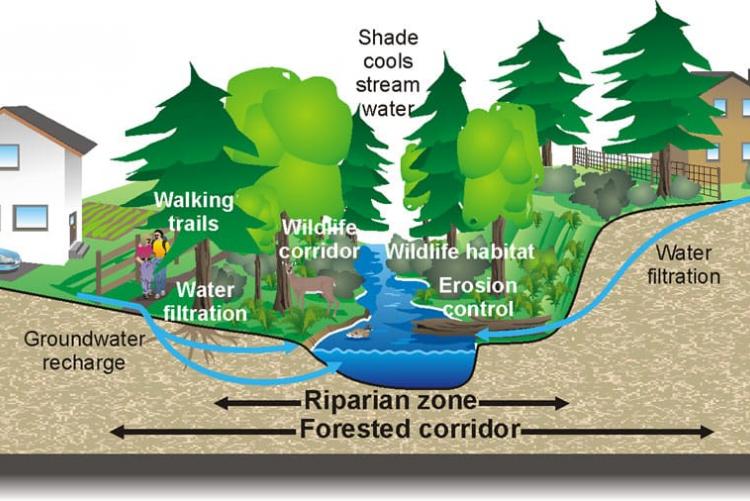
Land is arguably one of the most important natural resource in the country. Land especially in cities and urban areas is one of the most sought after commodity, basing on the number of land buying and selling companies and the rate of inflation of prices. Riparian land can be termed as land bordering water bodies such as rivers, streams and lakes. The term “Riparian Land’’ raised quite a stir recently when the government started demolitions of buildings deemed to be built on Riparian Land. This was occasioned by the collapsing of several buildings that were built near river banks in Nairobi. Currently due to the rise of rivers and lakes to the highest levels witnessed in decades, the question of how big Riparian Land should be once again arises.
Several rivers pass through Nairobi including Nairobi, Ngong and Mathare which are tributaries of Athi, the second longest river in the country. These rivers also happen to pass through some of the most densely populated areas in the city and therefore the issue of encroachment is a nightmare to Riparian Land conservation. The government demolishing buildings on Riparian Land came as a mitigative issue to prevent further building collapses. This led to an outcry by investors and residents of these developments as they lost property and to some a source of livelihood. It also raised the issue of regulation. In Kenya, there exists several laws protecting Riparian Land.
According to the Environmental coordination act of 1999, no development or cultivation should be done on a river bank between 6 to 30 metres on either side of a river bank depending on the highest ever recorded flood level. The water quality regulation act of 2006 prohibits building of permanent structures from a minimum of 6 metres to 30 metres from the top edge of a river which makes the laws contradictory in terms of the benchmark used.
In his publication in the Africa Habitat Review (Vol 14 No 3 (2020), Silas Muketha tries to address the control and contestation of Riparian zones in Nairobi river basin and their impact on conservation. The objective of his study was to map Nairobi River Basin and establish the number of structures build at 6, 10 and 30 metres from the river banks and propose a suitable plan for measuring Riparian zone widths.
Muketha acknowledges several essential life functions of Riparian Land such as maintaining stream flows, filtering chemicals and other pollutants, trapping and redistributing sediments, absorbing and detaining floodwaters, maintaining fish and wildlife habitats, and supporting the food web for a wide range of flora and fauna.
The study identifies contestation for space is one of the major setbacks in Riparian Land conservation. The concept of land also comes out strongly in a bid to understand the discrepancy between conservationists and other land users. From being a means of economical gain and status to a sacred provider for all the living things in the world, the view and use of land in the world is one of the most varied.
The study finds that only 40 % of the length of the rivers passing through the city falls on built up area. Informal structures also cover only 11% of the river. This has however had a big effect on the physical and biodiversity nature of Riparian Land along the rivers. The dumping of solid waste, garages and effluent from factories are some of the most adverse effects of passing through the built up area. Other notable land uses affecting Riaprian Land include quarries, informal and formal businesses, urban agriculture, sewers, high-income residential buildings, private institutions, open recreational spaces, public institutions as well as urban parks.
Riparian land reserve areas are also found to be indicated between 3 and 30 metres in some areas. It is also noted that establishment of Riparian land is largely based according to the flood plain.
The study finds that Riparian contestation and land control directly impacts conservation. There is also improper determination, use and management of these zones within the Nairobi river basins leading to encroachment and degradation by using land that is ecologically supposed to be riparian. There is also lack of GIS application to determine and manage Riparian Land. It also determines that decisions were based on isolated local physical development plans presented by registered planners to the County government for approval. There are also multiple applications of lower limit riparian widths without regard to the effects of adjoining or proposed land uses, biophysical characteristics, and the width of the river.
The study recommends the development of a GIS system to determine the extent of interference and aid in management and enforcement on the ground. There is also need to adopt the Nairobi City County GIS database as base map to absorb the proper extent of Riparian Land for the benefit of both the river and property. The City should enforce an agreed upon Riparian Land reserve as well as improve in waste management. To mitigate against floods, engineering solutions should be worked upon to protect property in the built up areas. In areas prone to flooding, there may be need to move some properties and a policy should be formulated to protect adjoining properties, rivers and Riparian Land reserves.
Read the full article HERE.
- Log in to post comments

